Tag Archive for: rock guide updates

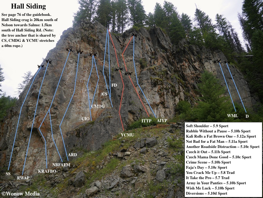
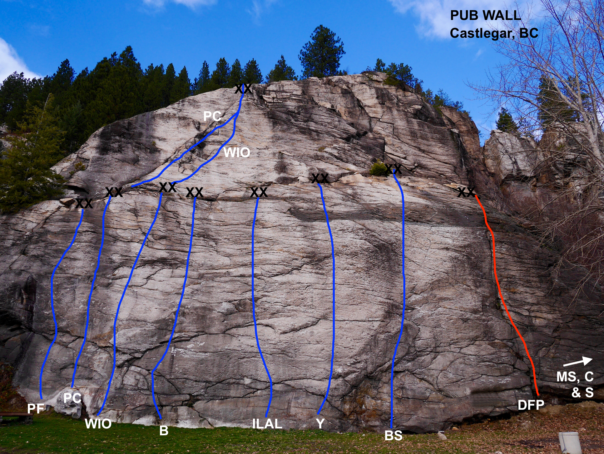
Pub Wall Rock Guide Updates

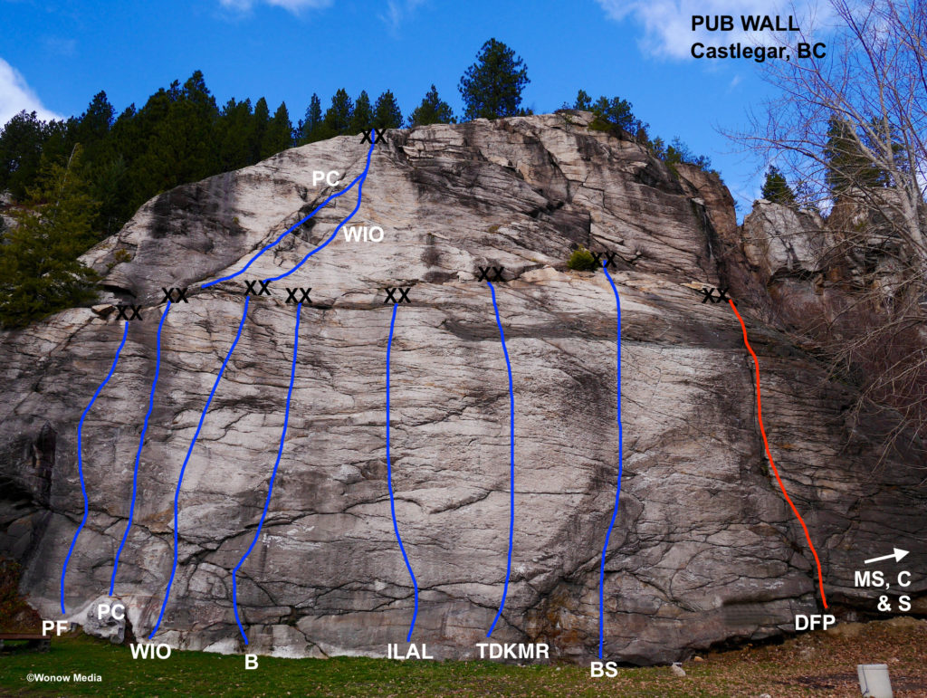
The Lion’s Head Smoke and Brew Pub in Robson, near Castlegar is a special place. Not only does it have an amazing selection of good beer on tap, it’s also Canada’s only rock climbing pub. Forty feet away from the back patio is the Pub Wall natural rock climbing cliff that boasts 11 quality routes. The owners of the Lion’s Head graciously allow us to climb here so we ask that you are respectful: don’t yell, swear or bring other beer onto the property. The bonus of this cliff is it sees early season sunshine. To access it follow the directions on page 19 of the West Kootenay Rock Guide then drive into the back parking lot of the Lion’s Head Pub. You can practically belay from your car here. It should be noted that another site published a topo for this wall but the information shared is inaccurate. There are no access issues for the three climbs around the right corner of the cliff (on the south-facing wall). However, further back and to the right are other cliffs that are on someone else’s property and the land owners there do not want people climbing on them. Here are the Pub Wall routes listed left to right:

Pub Fight 5.10d SPORT
The farthest route on the left. Climb the ramp to the steep face. There’s a definitive crux at the 2nd bolt. (A Kristiansen 11)

Pub Crawl 5.10b SPORT
This climb can be done in one 38m pitch or two pitches. Starts right of a shallow seam on the left side of the wall. P1: Climb off the boulder pedestal onto sustained face climbing with good rests. (5.10b) P2: From the first anchors follow the corner weakness up and right. Watch for a large loose block between the third and fourth bolt. (5.9) (P1: A Kristiansen, B Buten 10. P2: R Logtenberg, S Podstawskyj 11)

Walk it Off 5.9 SPORT
Starts 1.5m right of Pub Crawl. A long, fun route travelling over slabs and ledges. It can be done in 1 or 2 pitches. You can walk off or lower in 2 raps. 14 bolts. 38m. (R Logtenberg, S Podstawskyj 11)

Bender 5.10a SPORT
Start 5m right of Pub Crawl. Follow the crescent of rock up and to the right past 3 bolts. Then go straight and end at the ledge halfway up the wall. (Or continue on the upper half of Walk It Off.) 9 bolts. 20m (R Logtenberg, S Podstawskyj 11)

In Like a Lion 5.10d SPORT
As the name suggests, the route begins like a lion and goes out like a lamb. The crux is at the 3rd bolt – be aware of the ledge below you. 20m. (P Markin, K Robine 11)

Theodore Donald Karabotsos Memorial Route 5.10d SPORT
Named for one of the pub owner’s favourite movies and the “Big Lebowski” painting over the bar. This route tackles one of the steepest sections of the wall. Take small cams for the run-out through the easy terrain if you’re a nervous leader. (N Hadikin, B McIntosh, M Senyk 15)

Bar Star 5.10d SPORT
Start up the steep, right-facing feature and follow the obvious line of weakness over steep rock.
Pumpy below, balancy above, sustained throughout. (A Kristiansen 11)

Deep Fried Pickles 5.9 TRAD
A short finger crack on the right side of the main wall. (JT Croston, A Kristiansen 11)

The next three routes are located around the right-hand corner on the south-facing wall. This area doesn’t get as much sunshine and routes take longer here to dry out.

Maple Stout 5.10b TRAD
The obvious overhanging crack beside the tree. A #5 cam is useful. (B Winter, H Mutch 11)

Cheers 5.8 SPORT
Start at the short corner/break in the main face. P1: Climb the short corner, up easy slabs to a steeper section that ends at a belay ledge. 9 bolts. P2: Traverse right into the crack then up the face/slab to the top. 9 bolts. Descent: 2 raps or use the trail to the right. (B Winter, H Mutch 11)

Salut 5.8 TRAD
From the top of the first pitch of Cheers follow the twin cracks above. (B Winter, H Mutch 11)

This is part of a regular series showcasing the new rock climbing routes in the West Kootenay Region of south-central British Columbia. For more written descriptions of these and other routes, download the West Kootenay Rock Guide updates.

Champion Crag Rock Guide Updates

The trail-side boulder that marks where to turn right to access the cliff.

The trail-side boulder that marks where to turn right to access the cliff.

Champion crag is located high on the east rim of the Columbia River valley south of Castlegar. The cliff can be seen from the highway (near Genelle) as a band of dark rock surrounded by lighter coloured rock on all sides. There is also a large, left-leaning crack near the center of the cliff. Access: This crag is one of the longer approaches in the area: it’s a 40-minute walk or 15-minute mountain bike ride along the well-maintained Mel Deanna trail. From Castlegar drive Hwy 3 towards the Bombi summit and Salmo for 5km and then turn right into the viewpoint/rest area. Park here and follow the trail past the viewpoint and through the gate. Walk or mountain bike along the trail making sure to stay right at the first A-frame shelter. Just past interpretive trail marker #6 you’ll come to a large trailside boulder and 40m past that you’ll branch right onto a smaller trail marked with rock cairns. Follow these for 5 mins to the top of the crag where the trail angles back and down to the right and then ends at a 5m drop to a large ledge. There is a rebar ladder here you can use to descend to the ledge where the climbs start.  A 60-metre rope is required. For written descriptions of these and other routes, download the West Kootenay Rock Guide updates.

This is the first climb you reach after descending the rebar ladder.

This is the first climb you reach after descending the rebar ladder.

Champion Crag Rock Guide Updates: This is the 11th in a regular series showcasing the new rock climbing routes in the West Kootenay Region of south-central British Columbia. For written descriptions of these and other routes, download the West Kootenay Rock Guide updates.

Marley Bassett prepares to clean Son of a Birch.

Polished Wall Rock Guide Updates

Polished Wall is located at Kinnaird Bluffs in Castlegar, British Columbia. Follow the trail up and to the left (North) from Open Book Wall (page 29 of the West Kootenay Rock Guide). It’s an excellent wall for beginner sport and trad climbers although it’s important to note that the anchors are not easily accessible from above.

In order to fit most of the routes on the main wall into one topo image, a fish-eye lens was used so you’ll notice some of the distances appear skewed. The two-pitch routes Reflections, Via Escondida and Lazy River all require two rappels as they top out around the 37m mark.

For route and access descriptions please download the West Kootenay Rock Guide updates.

Marley Bassett prepares to clean Son of a Birch.

Marley Bassett prepares to toprope Son of a Birch.

RFW Wall Rock Guide Updates

RFW Wall is located just past Scottie’s Marina on Broadwater Road. It features five of the best moderate trad/mixed routes in the area. However, please note there is poison ivy in this area. Steps have been taken to eradicate it but it’s wise to be wary of any plant with “leaves of three.”

For route and access descriptions please see page 21 of the West Kootenay Rock Guide. For a written description of La Femme Fromage, download the West Kootenay Rock Guide updates.

RFW Wall Rock Guide Updates: This is the 12th in a regular series showcasing the new rock climbing routes in the West Kootenay Region of south-central British Columbia. For written descriptions of these and other routes, download the West Kootenay Rock Guide updates.

Wapiti Wall Rock Guide Updates

For further descriptions about climbs in the Arrow Lakes area near the community of Castlegar in south-central British Columbia, Canada, refer to page 19 of the West Kootenay Rock Guide. Access: This wall has, arguably, the easiest access in the Kootenays. (The name comes from the Cree word for “elk.”) It is located 650m south of Scottie’s Marina. You can’t miss it as you drive towards Scottie’s because the wall is so close to the road it’s practically on it. For parking, the best option is to do a U-Turn at Scottie’s, drive back to the wall and use the narrow pullout on the lake side of the road. There are three separate walls here with 14 climbs on them. Please note, Parting Gift has been overrun with poison ivy lately. Directors of TAWKROC will be dealing with it soon but in the meantime, please avoid any plants with “leaves of three.”

The Wapiti Wall Rock Guide Updates: This is the tenth in a regular series showcasing the new rock climbing routes in the West Kootenay Region of south-central British Columbia. For written descriptions of these and other routes, download the West Kootenay Rock Guide updates.

The Ant Hill Rock Guide Updates

For further descriptions about climbs at the CIC Slabs area in the city of Nelson in south-central British Columbia, Canada, refer to page 61 of the West Kootenay Rock Guide. Access: The Ant Hill is located just below the Sunnyside Crag near the West side of the Svoboda parking lot. (See page 67 of the West Kootenay Rock Guide for a description on how to reach the Sunnyside Crag). This is a good wall to take your young kids to because it’s easy to walk to (it’s only 40 feet away from the parking lot), the anchors are easy to reach from above and it offers the only documented 5.2 in the area.


The Ant Hill Rock Guide Updates: This is the ninth in a regular series showcasing the new rock climbing routes in the West Kootenay Region of south-central British Columbia. For written descriptions of these and other routes, download the 2014 West Kootenay Rock Guide updates.

This shows where you can find the Svoboda parking lot in Nelson and where Sunnyside and Ant Hill are located in relation to it.

Yellow Sling Wall Rock Guide Updates

For further descriptions about climbs at the Kinnaird Bluffs area in the community of Castlegar in south-central British Columbia, Canada, refer to page 27 of the West Kootenay Rock Guide.

Access: See page 35 of the West Kootenay Rock Guide for a description on how to reach the Yellow Sling Wall and Red Rocks Wall from the Kinnaird parking area. This wall is an excellent early/late season one but tends to be a solar oven in the height of the summer. It offers everything from 5.4 trad to 5.12+ sport and the four pack of Extended Vacation, Yellow Sling, Glory Hole and Bakers Day Off are definite must-dos. However, note that the last two are 28m long and you’ll need 14 quickdraws for Glory Hole.

As with all climbing at Kinnaird, please be respectful of the nearby neighbours – these walls act like natural amphitheaters and every word you utter can be heard with surprising clarity by nearby residents. Also, do not cut through anyone’s yard or property to access the crags.

Yellow Sling Wall Rock Guide Updates: This is the eight in a regular series showcasing the new rock climbing routes in the West Kootenay Region of south-central British Columbia. For written descriptions of these and other routes, download the West Kootenay Rock Guide updates.

This overview of Kinnaird Bluffs shows Yellow Sling Wall and Red Rocks wall in relation to the seven other walls at this area.

Zebra Wall Rock Guide Updates

For further descriptions about climbs in the Arrow Lakes region between the community of Robson and Syringa Provincial Park in south-central British Columbia, refer to page 19 of the West Kootenay Rock Guide. Access: Zebra Wall is located on Broadwater Rd. just north of Scottie’s Marina and around the first corner. There are five sport climbs there ranging from 5.10a to 5.11b and the tallest is 28m long. (You’ll need 14 quickdraws.)

Zebra Wall Rock Guide Updates: This is the seventh in a regular series showcasing the new rock climbing routes in the West Kootenay Region of south-central British Columbia. For written descriptions of these and other routes, download the West Kootenay Rock Guide updates.

Hall Siding Rock Guide Updates

For further descriptions about the climbs at Hall Siding between Nelson and Salmo, British Columbia, refer to page 76 of the West Kootenay Rock Guide. Access: Hall Siding is located 20km south of Nelson towards Salmo. (Note: The WKRG erroneously stated the crag’s position in relation to Hall Siding Road – it is, in fact, 1.5km south of the road.)

Hall Siding Rock Guide Updates: This is the sixth in a regular series showcasing the new rock climbing routes in the West Kootenay Region of south-central British Columbia. For written descriptions of these and other routes, download the 2014 West Kootenay Rock Guide updates.

Ymir Swimming Hole Rock Guide Updates

To reach Ymir Swimming Hole’s Southern Bluffs, continue past the Lower Bluffs on the path towards the swimming hole for about 30m. On the right take the faint trail (it’s opposite the path to the river.) There are a few small faces tucked in this area:

Ymir Swimming Hole: This is the fifth in a regular series showcasing the new rock climbing routes in the West Kootenay Region of south-central British Columbia. For written descriptions of these and other routes, download the West Kootenay Rock Guide updates.